A source of Clyde
The true source of a river can be a notoriously difficult, not to mention contentious, thing to pin down. When I say the source I don’t mean the location at which a water course takes its name, but — rather — the actual point where it bubbles from the ground. I’d go further than that. Not only do I consider it the point where it first comes out of the soil, it should be the farthest point in the catchment from the sea. Take the River Thames as an example. Wikipedia has this to say:
Thames Head is the traditional source of the River Thames. While the Environment Agency, the Ordnance Survey, and other authorities have the source of the Thames as Trewsbury Mead (Thames Head), others hold that the true source of the Thames is at Seven Springs, Gloucestershire, the source of the River Churn, which is a tributary of the Thames.
These things matter. In the case of the Thames, if the River Churn were counted as its true source (which I think is an unassailable argument) then it adds 14 miles to the length of the Thames, thereby making it 9 miles longer than the Severn, and — by extension — the longest river in Britain. (Link here.)
Of Scotland’s major rivers, it seems to me that only one hasn’t had its source adequately identified: the Clyde. The Tay, we know, rises on the slopes of Ben Lui. The Dee, famously, issues from the ground at 4000 ft on Braeriach via the remarkable Wells of Dee. The Spey’s origin can easily be traced to the streams that feed Loch Spey, high in the heart of the Corrieyairack Forest in the Central Highlands.

For all its historical importance, though, it is somewhat surprising that the River Clyde’s ultimate root remains contentious, with no real universally agreed location. As far as I can tell, the current authority for the Clyde’s genesis lies with Tom Weir’s account of a trip many years ago. But even that chronicle shirked identifying the actual source. Weir spoke of ‘hop(ping) across the true source of the Clyde’, but actually this was some distance downstream from where the burn in question, the ‘Thick Cleuch’, ultimately rises. (The precise location where he hopped across the burn is here.)
A more detailed account of the Clyde’s true source is found in Richard Happer and Mark Steward’s book The Clyde: From Source to Sea. Even this, though, only speaks of the general area of Thick Cleuch Moss when viewed from above.
Is Thick Cleuch really the source of the River Clyde?
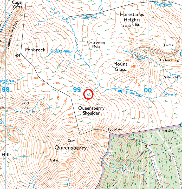
It is beyond debate — and universally accepted — that, before the Clyde is actually called the Clyde, it is styled the ‘Daer Water’. The Clyde as we know it starts when the Daer meets the Potrail Water, as shown by the red circle in the map below. The name ‘River Clyde’ is first shown on the Ordnance Survey map just a mile or so to the north.

If we follow the Daer Water back (upstream) a few miles we can see it issues from the man-made Daer Reservoir. This large body of water is fed by numerous streams. The main ones — and the ones we are concerned with in this article — are the two decent-sized water courses at its southern end: the Daer Water (again) and the Crook Burn, slightly to the east.

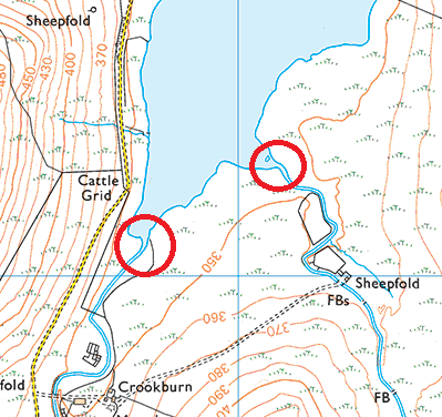
These two streams are roughly the same size in terms of width and volume. At least, that’s how the map portrays them. This got me thinking. Writers and walkers have taken for granted that the true source of the Clyde has to be a feeder of the Daer. Not unnaturally I suppose, given that this river eventually morphs into the Clyde farther downstream. But the Daer’s sister, the Crook Burn, just a few hundred metres away, seems to have been neglected. It occurred to me that a visit to the source of both of these streams would be a good way to try and solve this conundrum.
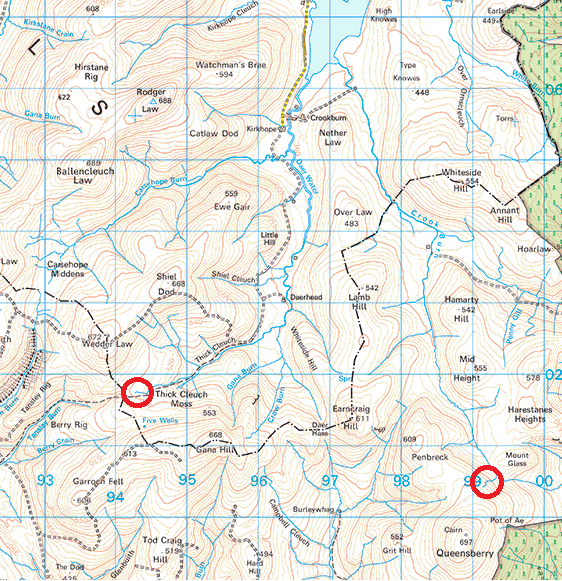
A few things struck me when I was looking at the map in the car just before I set off on the morning of 5 November 2017. The first was that the source of the Thick Cleuch was quite a bit closer to the reservoir than that of the Crook Burn. Or, to put it another way, the source of the Crook Burn is farther from the sea than the head of the Thick Cleuch, and also farther south. Secondly, why was the Thick Cleuch preferred as the source stream of the Clyde when the Daer Water maintains its own name right back to its source, here? Surely for consistency the latter ought to apply? It also added weight, as I saw it, to the notion that the Crook Burn ought to be considered as a contender as the true source. (i.e. the Daer is discarded as the source because the Thick Cleuch is apparently larger and longer.)
November 5, 2017
The day was cold and clear when I set off at about 10.15am. The plan was to follow the Land Rover track from Kirkhope and then pick up what I imagined was a stalkers’ track up Thick Cleuch Moss. Though the former was lovely and afforded good walking, the latter didn’t — in fact — exist, despite the promise from the OS map. Typical.
Finding a small water course high on a heathery hill is not a straightforward endeavour even with the aid of modern technology. Bog-hopping is something that I’m well used to, but even this was hard going. It’s not always easy just to follow a water course, as they frequently disappear and reappear, often where you don’t expect them. Up and up I went, in any case, trying all the while to pass the large squelching bogs and leaping over the smaller streams when they presented themselves. Eventually, though, I approached what appeared to be the very top of the Thick Cleuch. The OS map agreed. According to Tom Weir, this rivulet before me was the true source of Scotland’s second longest river.
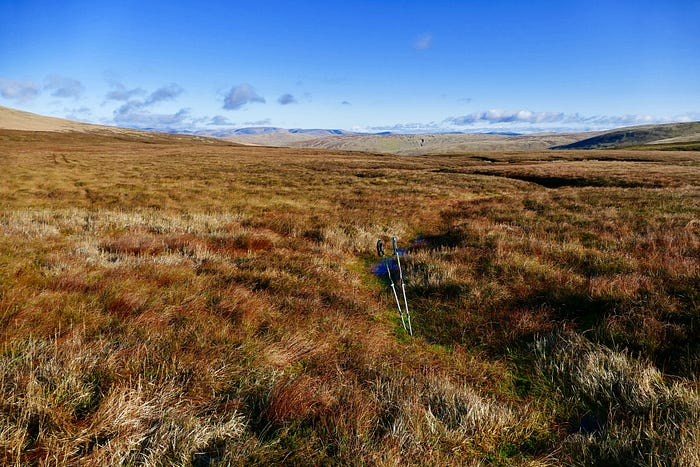
I must confess that I was a bit underwhelmed by the location. I wasn’t exactly expecting nymphs or sirens, but it just seemed a little… disappointing. There was lots of rough ground on either side and the spring itself looked a little bit sorry for itself. Actually it was more a spurt than a spring.
Unsatisfied, I decided to make for the source of Crook Burn. I knew it was a good few miles away, but time was on my side, and the day was as good as one could hope for in early November in the high ground of Southern Scotland.
The views en route were magnificent. From the summit of Gana Hill I could see as far as the Isle of Man to the west, and the Galloway Highlands to the south-west. Not even the sub-optimal underfoot conditions could mar what were marvelous vistas in virtually every direction.
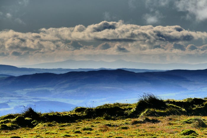
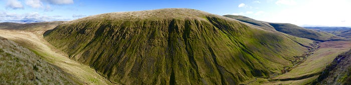
A herd of wild goats greeted me as I contoured around Penbreck on the final approach to Queensberry, where I hoped to find the Crook Burn’s birthplace, sitting on its norther shoulder. The views were much more airy and wide-ranging than the Thick Cleuch’s. This felt a far more fitting place for the source of Scotland’s most famous river. When I did happen across the spring it was much more like what I expected it to be: lush, verdant, watery.


I sat by the green moss and had lunch. As I ate I used an app on my phone to measure the distance from this location to the Daer Reservoir. It was 3.9 miles as the crow flies: one mile more than Thick Cleuch’s equivalent distance. It was also 40 metres higher and a couple of miles farther south. Both of these facts surely bolster its claim?
When eventually I did get back to near the start of the walk, through some of the roughest ground I’ve ever walked on, I ventured to where both streams enter the Daer Reservoir, ostensibly to see what I considered the largest upon entry. Though undoubtedly size isn’t everything, it would be interesting to see nonetheless.

My own very unscientific calculations suggested that the two streams were virtually identical in their volume. I don’t suppose they’ve ever been measured, but perhaps close to a third of one cubic metre per second (300 litres) seems about right.
Conclusion: if it were down to me I’d award the title of ‘True Source of the River Clyde’ to the Crook Burn, high on the northern escarpment of Queensberry. If nothing else it’s the point in the catchment area of the River Clyde that’s farthest from the sea (or, in technical terms, it’s hydrologically the longest tributary). It’s also every bit as large as Thick Cleuch. These attributes ought to, I contest, win the day for the Crook Burn.
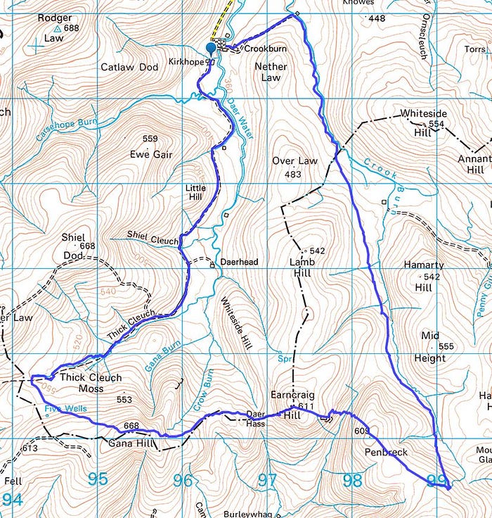
Route:
EDIT: A picture of another contender for the Clyde’s true source.
